Tamworth, Staffordshire - Live Weather Station

8°C
Tamworth, England
Language:  English
Updated:  18-Dec-2025 19:10 
  Night time, Dry, Clear Temperature: 8.0°C Colder 0.5°C than last hour.   -0.5°C/hr Humidity: 98%Decreased 1.0% since last hour. Dew Point: 7.7°CDecreased 0.6°C since last hour. Wind: SSE  4.7 mph Gust: 5.8 mph Barometer: 995.8 hPaRising 1.7  hPa/hr  Rising Rain Today: 22.1 mm UV Index: 0.0  None

Navigation

  • Home
  • PWS Dashboard
  • Cumulus-MX Dashboard
  • 7 Day Forecast
  • Local/UK Radar
  • Weather Warnings
  • Temperature Map
  • Precipitation Map
  • Wind Map
  • Surface Pressure Charts
  • Clouds/Satellite
  • Lightning Map
  • UV Index
  • GFS Model/GEFS Ensembles
  • Jet Stream
  • Snow Risk
  • Sunshine Hours
  • Sea Temperatures
  • Temp/Rain Averages
  • Frosts/Freeze Data
  • Station Trends
  • Station Graphs
  • Local Climate Data
  • Station History
    • Daily History
    • Monthly History
    • Seasonal History
  • Station Records
    • Daily Records
    • Current Month Records
    • Current Year Records
    • All Time Records Since 2001
  • World Extremes
  • Global Climate Temperatures
  • Sun/Moon Almanac
  • Aurora Forecast
  • Astrophotos
    • Deep Sky Objects
    • Widefield
    • Moon/Stars
    • Northern Lights
  • Earthquakes
    • Earthquakes UK
    • Earthquakes World
  • About Us
  • Station System Status

Mobile Weather

Get TamworthWx SmartPhone Weather QRCode2Scan With Phone's Bar Code Reader


Support Website


Buy Me A Beer

UK Extremes


Past 24 hours
 
High Temp
Bude
12.8 C
 
Low Temp
Shobdon
-3.4 C
 
Precipitation
Whitechurch
48.2 mm
 
Sunniest
Manston
3.9 hours

© Crown Copyright 2025 Met Office

Cloudbase


Sunlight


7 h 38 m 36 s
of Sunlight Today

Which is
21
sec shorter.
than yesterday

7 h 38 m 21 s
of Sunlight Tomorrow
(Noon)
graph
(Midnight)

Moon Phase

 moon cycles

Links

Weather Underground PWS ITAMWORT22
spacer
Countdown to Winter
 Winter Solstice begins December 21st at 3:03pm   GMT  
 
METRIC | IMPERIAL
Updated: 18-Dec-2025 @ 19:10   (0 sec ago)
Temperature Current Conditions Forecast / Rain Radar

Currently: 8.0, Max: 10.4, Min: 7.9

8.0°C

Temp Trend Colder 0.5°C than last hour.

Cold

Feels like: 7°C

24-hr difference
-0.7°CColder 0.7°C than yesterday at this time.
High Today
10.4°C
1:38 AM
Low Today
7.9°C
7:06 PM
Yest High
10.0°C
11:59 PM
Yest Low
-0.2°C
12:30 AM
Year High
32.3°C
11-Jul-2025
Year Low
-6.2°C
11-Jan-2025
*Rec High
38.7°C
19-Jul-2022
*Rec Low
-12.2°C
25-Dec-2010
* This Station's Records Since 1/2001
Night time, Dry, Clear Night time, Dry, Clear

Wind from SSE Wind:  SSE
4.7

Gusting to:
5.8 mph
Current Rain Rain:
22.1 mm
Chandler Burning Index: LOW Current CBI
Fire Danger:
-2.2 of 100
Tonight

Chance rain
Chance rain
Friday

Partly Cloudy
Partly Cloudy
Friday
night
Fog
Fog
Low: 6° High: 8° Low: 2°

Click here for Full Local 7 Day Forecast
SPC Activity Map
Dew Point Rainfall Wind Speed Sun / Moon
Current: Decreased 0.6°C since last hour. 7.7°C
Last Hour: Decreased 0.6°C since last hour. -0.6°C
High 1:38 AM: 9.8°C
Low 7:06 PM: 7.6°C
Record High: 22.1°C on
25-Jul-2019
Record Low: -14.2°C on
5-Apr-2021
Wetbulb: 7.9°C
Rain Rate (/hr)
rain graph

Today: 22.10 mm
Yesterday: 5.10 mm
Last 7 Days: 31.00 mm
Dec Rain: 89.40 mm
Dec to Date
  Avg:10
47.04 mm
Dec to Date
  Diff from Avg:10
Over 42.36 mm for the month 42.36 mm
Season:1 672.5 mm
YTD
  Avg:11
698.74 mm
YTD
  Diff from Avg:11
Under 26.24 mm for the year 26.24 mm
Last Rain
Time/Date:
18-Dec-2025
at 5:38 PM
143 rain days in 2025
14 days in December
0 days since last rain
Current: SSE  4.7 mph
1Hr Average: 1.1 mph
Wind Run: 37.47 miles
Wind Gust
Current: 5.8 mph
Today: 25.5 mph 12:16 AM
Month: 42.1 mph 9-Dec
Year: 48.3 mph 24-Jan
Record Gust: 69.0 mph
9-Feb-2020
Sunlight:
7 h 38 m 57 s
of Sunlight Yesterday
7 h 38 m 36 s
of Sunlight Today
Which is 21 sec shorter than
yesterday
7 h 38 m 21 s
of Sunlight Tomorrow
(Noon) graph (Midnight
Legend

Waning Crescent
Waning Crescent, 28 days, 12 hours, 27 minutes in cycle
1%
Illuminated
Humidity Barometer
Current: Decreased 1% since last hour. 98%
Last Hour: Decreased 1% since last hour. 1%
High 3:56 PM: 99%
Low 3:54 AM: 91%
Record High: 99%
11-Feb-2001
Record Low: 20%
27-Jul-2022
Current: Rising 1.7  hPa/hr 995.8 hPa
Last Hour: Rising
High 7:40 AM: 1005.2
Low 4:40 PM: 993.3
Record High: 1046.4 hPa
20-Jan-2020
Record Low: 962.0 hPa
10-Mar-2008
Heating Degree Days Lightning Strikes Wind Chill Air Quality
Today: 6.0
Dec: 184.2
2025 to Date: 2532.9
Cooling Degree Days
2025 to Date: 84.4
Last Min: 0
Last 5 Mins: 0
Last 30 Mins: 0
Last 60 Mins: 0
Last 12 Hrs: 0
Dec: 111
2025 to Date: 119
Current: 6.8°C
Low 7:07 PM: 6.5°C
Yesterday: -1.9°C
Record: -15.9°C
31-Mar-2013
UV Summary/Forecast Solar Summary
High Today:   0.0 @ 12:01 AM
Dec-19

0.4
Dec-20

0.3
Dec-21

0.4
High Today:  
29 W/m2 @ 11:01 AM


Sunrise: 8:17 am

Sunset: 3:51 pm
Almanac Irrigation Index5 Station All Time Records Cloud Level
Currently: Evening
YTD Avg Temp: 11.1°C
Sunrise: 8:17 am
Sunset: 3:51 pm
Moonrise: 7:26 am
Moonset: 1:57 pm
Full Moon: 04-Dec-2025
New Moon: 01:44 UTC
20-Dec-2025
Updated at Midnight
Current ET: 0.30 mm
7-Days Rain: 31.00 mm
7-Days ET: 2.60 mm
7-Day:  28.4 mm water in excess of what evaporated in last 7 days. 28.4 mm
December:  523.9 mm water in deficit of what evaporated this month. 523.9 mm
HIGHS: LOWS:
38.7°C
19-Jul-2022
-12.2°C
25-Dec-2010
Daytime Records
  37.7°C°C
19-Jul-2022
  -4.0°C°C
28-Feb-2018
Nitetime Records
  26.5°C°C
20-Jul-2022
  -9.2°C°C
25-Dec-2010
ICN:1 | S3C2:4 | Ajax 3.xx
ISS:Ok |
1 Rain season: Jan 1st to Dec 31st.   2 Snow season December 1st to November 30th.   3 Snow manually measured usually around 7AM and 7PM.   5 Estimated amount of water needed to replace the water used by plants and evaporation from the past week. (Negative numbers mean amount of water needed, positive numbers mean excess water is present).   6 Air Quality Index is provided by aqicn.org and is updated hourly.   10 Historical average only to day 18 of just the month of December for this station since 2001.   11 Historical average rain this season to day 18 of December for this station since 2001.
 WXSIM Tamworth Weather Forecast  -   Outlook Tonight & Friday
Tonight

Chance rain
Chance rain
Low: 6°
WXSIM forecast: Cloudy in the evening, becoming mostly cloudy after midnight. Moderate fog in the evening. A chance of rain in the evening, then a slight chance of rain after midnight. Breezy. Low 6°. Wind southwest around 12 mph, gusting to 22 mph. Chance of precipitation 40 percent. Precipitation mostly around 2 mm.
 
Friday

Partly Cloudy
Partly Cloudy
High: 8°
WXSIM forecast: Partly cloudy. Breezy. High 8°. Wind southwest around 11 mph, gusting to 19 mph.
 WXSIM Tamworth Short Term Weather Forecast
Friday
night
Fog
Fog
Saturday

Fog a.m.
Fog a.m.
Saturday
night
Chance rain
Chance rain
Sunday

Rain likely
Rain likely
Sunday
night
Fog
Fog
Monday

Fog a.m.
Fog a.m.
Low: 2° High: 8° Low: 8° High: 9° Low: 7° High: 9°
  WXSIM Tamworth Meteogram Forecast
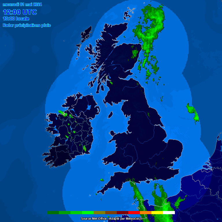
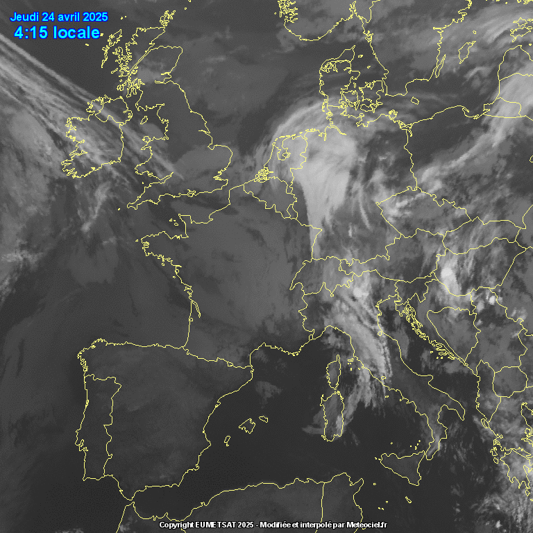
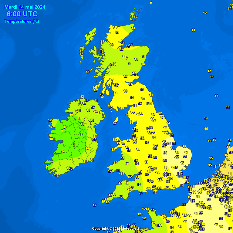
  Pressure / Cloud Satellite / Temperatures
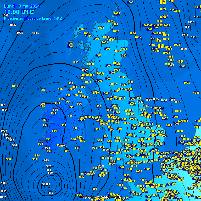
Top | Contact Us
© 2025, Tamworth Weather Station | Weather-Display (10.37S-(b152)) | Valid XHTML 1.0 | Valid CSS

Never base important decisions on this or any weather information obtained from the Internet.